Brian Ettling by Copper Harbor in the Upper Peninsula of Michigan with Lake Superior behind him. Photo taken on April 10, 2010.
“No more turning away From the weak and the weary No more turning away From the coldness inside Just a world that we all must share It’s not enough just to stand and stare Is it only a dream that there’ll be No more turning away?”
This is part 6 of my 6 part blog from 2004-2010 how the EarthBall became my symbol. I conclude these multi-part story how my April 10, 2010 photo of me with my EarthBall at Copper Harbor, Michigan with Lake Superior behind me became my favorite Earth Ball photo.
Part 6: Getting my ideal EarthBall photo in Copper Harbor, Michigan in April 2010
On April 10th, Dan and Cherie first took me to see Haven Falls waterfall, located in Haven Falls Park. I took four photos of this 20-to-30-foot narrow waterfall that flows down a steep rocky hill like a snow sled. It was next to the road and some picnic tables, so we did not have to hike to go see it. We then walked for a while on Point Isabelle Beach, located on a lower northeastern bulge of land with eastern facing views of Lake Superior and the interior westward looking Bete Grise Bay. No other people were there as we strolled on this red clay beach interrupted by some large random stones. All three of us got lost in our thoughts in the serenity of the area. The only sound was the spring breeze making the Lake Superior water have small ripples.
We then drove a couple of miles west to see the Lac La Belle Lake with Mount Bohemia, a 1,467-foot mountain nestled on the back side of the lake. From there Dan drove many miles on a dirt backroad as far as he could get to the eastern most part of the peninsula, Keweenaw Point. It felt like we drove through many miles of forests, but we could not get to the edge because another forest stopped the dirt road before we could go any further.
We then backtracked to drive to Copper Harbor, the northern most point of the Keweenaw Peninsula and the U.P. We spent some time hanging out by the rocky shoreline admiring the Copper Harbor Lighthouse a short distance across the Copper Harbor Bay. This was a small lighthouse with a black top cupola, black gallery, beige tower and attached building with a reddish roof. I took several photos of the lighthouse zoomed in to see it more up close and zoomed out to see more of Copper Harbor and Lake Superior next to the lighthouse.
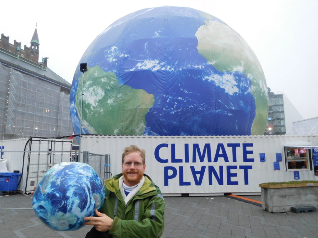
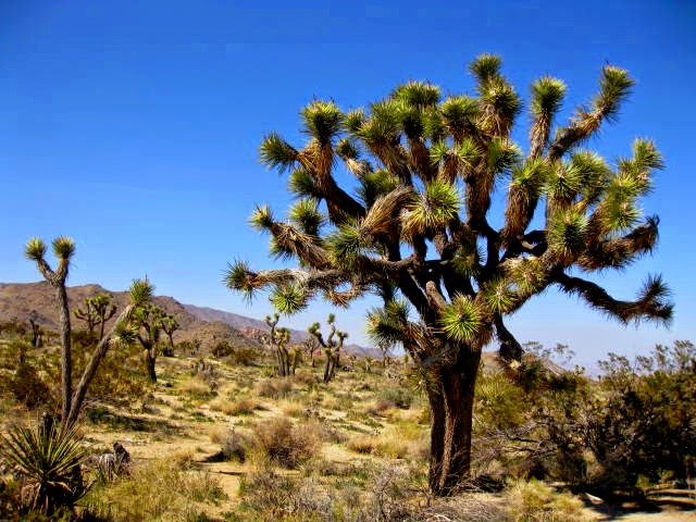
At the rocky shoreline by Copper Harbor, I decided to inflate my Earthball. I then asked Dan to take my photo holding it while I stood on the brown rocky shoreline. The dark blue waters Lake Superior and the blue spring sky was behind me. We took several photos, so I had options to choose from to create an iconic photo of myself.
Brian Ettling by Copper Harbor in the Upper Peninsula of Michigan with Lake Superior behind him. Photo taken on April 10, 2010.
When I looked at the photos afterwards, I was most pleased with the landscape photo of me at this location. It was late in the afternoon, around 5 pm. The sun was low enough in the sky to create an ideal photo of the sun illuminating me. A year later, I chose this photo for my Facebook Profile photo and as the image for my business cards. I think it is the best symbol of me. Although that photo is now almost 16 years old, I don’t want to change it. I was so happy to see Lake Superior on this trip. I like using a photo using a large body of water meeting the sky, representing that over 70% of the planet is covered with water. Yet, standing on this brown rocky ground represents the solid ground of the Earth were almost all humans live.
The only odd part of the photo is that the horizon is noticeably uneven. However, I accept that as part of the quirk of the photo. I kept it uneven for my Facebook profile photo. In my climate change presentations since then when I used the photo, I edited it to make the horizon even so it would not be distracting.
In the years afterwards, I took my photo with the Earth Ball in many of my favorite places. I was born and raised in St. Louis, Missouri. Thus, I had my photo with taken with the Earth Ball with the Gateway Arch and the St. Louis downtown skyline behind me in January 2018. The day after my wife Tanya and I moved to Portland, Oregon in February 2017, I posed with the Earth Ball on top of Council Crest with the downtown skyline of Portland behind me. Over the last 10 years, I lobbied for climate action in Washington D.C. for Citizens’ Climate Lobby. In November 2018, I held my Earth Ball in front of the U.S. Capitol Building.
Tanya is Danish American. My mother-in-law is originally from Denmark. I love traveling to Denmark with her to see her aunts, uncles, and cousins. In October 2017 in the middle of Copenhagen, held a Climate Planet Exhibit. It was a 30-seat theatre inside a large Earth Ball showing a short documentary to create more awareness about climate change. My wife Tanya took my photo with my inflatable Earth Ball with the giant Earth Ball theatre behind me.
Photo of Brian Ettling in front of the Climate Planet Exhibit in Copenhagen, Denmark on October 20, 2017.
I worked as a seasonal park ranger at Crater Lake National Park from 1992 to 2017. I used my Earth Ball for numerous ranger talks. I posed for numerous photos with it for various promotions. Tanya and I took a photo of the Earth Ball soon after engaged in December 2014. We had the Earth Ball featured in our ceremony wedding on November 1, 2015. The official wedding photographer took a photo of Tanya and I holding the Earth Ball as part of our official wedding photos. I had the Earth Ball with me when I taped my appearance on Comedy Central TV’s Tosh.o in April 2016 for the episode that aired on August 2nd of that year. On September 21, 2025, I showed up, marched, posed for photos, and even shot of quick video of me walking with my Earth Ball for the nationwide Third Act Sun Day Marches to promote solar and clean energy.
I first started using the Earth Ball back in 2004 when I worked as a seasonal park ranger giving ranger talks at Everglades City Visitor Center in Everglades National Park. Sadly, I don’t think I have of myself with my Earth Ball then. However, it has been part of my life in countless photos since then. My favorite to this day is the photo in Copper Harbor Michigan with Lake Superior behind me. The U.P. of Michigan is one of the most beautiful places on planet Earth I have seen. I have wanted to return there since then, but the opportunity has not presented itself yet.
As far as the rest of this trip to the U.P, we did a bit more sightseeing after we captured the iconic photo. I was curious to walk east down the road past Copper Harbor to see what was there. I encountered a small clear pond surrounded by a few pine trees and a gentle sloped mountain behind it. It was called Mud Pond, but the water was completely still with good clarity to see the shadow bottom. The pond was so calm that it reflected the trees and the brown tall still hibernating grasses and bushes along the shoreline. The still water also acted like a mirror showing the clear bright blue afternoon sky. We then walked by another inland lake, much bigger that did have a ripple of disturbance on the water surface. This lake was so large that we did not have time to walk around it. We had just enough time to admire the pine trees that ringed and surrounded the lake with the pine tree forest continuing up a forested long ridge.
As we left Copper Harbor, I noticed a sign indicating it was the beginning of U.S. Highway 41 and stating that Miami, Florida was 1,990 miles away. When I worked in Everglades National Park, I spent my last four seasons working at the Everglades City and Shark Valley Visitor Centers. They were located off U.S. Highway 41 and about an hour drive from Miami, Florida. I now felt like I came full circle. Everglades National Park was where I first learned about climate change, decided I wanted to dedicate my life to educate others to act, and I first started using an Earth Ball in my ranger talks. It was surreal that I was at the other end of U.S. Highway 41, nearly 2,000 miles from Everglades National Park and Shark Valley. I had no idea on this day that I would end up at the northern terminus of Highway 41. My friend Cherie Barth was working with me in the Everglades around the year 2000 when I first started learning about climate change.
Photo by Brian Ettling on April 10, 2010 at the sign by Copper Harbor, MI indicating the northern start of U.S. Highway 41 and the distance to the southern end of Hwy 41 in Miami, Florida.
My ideal EarthBall Photo Set me on my life’s path to be a Climate Change Organizer
Now I was at the other end of the road getting my perfect photo of me holding an Earth Ball to try to promote climate action. In future blogs, I will share where the road of life took me next for the rest of this trip to the U.P. of Michigan and Wisconsin. Soon after I returned to St. Louis, Missouri from this trip, my friend John Dantico help me set up the www.climatechangecomedian.com website that I use to this day. I practiced my Climate Change Comedian PowerPoint with my ranger friends at Crater Lake National Park that summer. I then showed it to other friends on my cross-country drive from Crater Lake to St. Louis that autumn of 2010.
In February 2011, I started this blog and I joined South County Toastmasters to be a better climate change public speaker. In March to May 2011, I worked at the temporary Climate Change Exhibit at the St. Louis Science Center. In August 2011, I gave my first climate change evening campfire ranger program at the Crater Lake National Park campground amphitheater. In September 2011, I attended the Earth to Sky V: NASA, the U.S. Fish & Wildlife Service National Park Service training for Communicating Climate Change in Shepherdstown, West Virginia.
In November 2011, local businessman Larry Lazar and I co-founded the Climate Reality St. Louis Meet Up group, now called Climate Meetup-St. Louis. In December 2011, I attended the American Geophysical Union or AGU conference in San Francisco. My friend and fellow climate change organizer, Tom Smerling, who I first met in Washington D.C. in October 2011, encouraged me to attend the AGU conference. It was a rewarding opportunity to meet the top climate scientists of the world, such as Dr. James Hansen, Dr. Michael Mann, Dr. Richard Alley, and others and see their climate change presentations.
During the monthly St. Louis Climate Reality Meet Ups in early 2012, Tanya Couture showed up at these meetings. We struck up a friendship, started dating in 2013, and got married on November 1, 2015. Tanya has always been very supportive of my climate organizing, and a joy to be around. I was finally free of awkward dating experiences and the frustration of being single!
In April 2012, I wrote an article published in Yale Climate Communications, “Communicating Climate Change in a National Park.” In May 2012, I first became involved as a volunteer with Citizens’ Climate Lobby. In August 2012, I attended my first Climate Reality Project Training led by former Vice President Al Gore in San Franciso, California. I became a Climate Reality Leader and then a Climate Reality Mentor in August 2013. I eventually gave over 200 to 300 climate change talks in 12 U.S. states, Washington D.C, and Ottawa, Canada. Two of my most memorable experiences was speaking at the Shine of the Ages Auditorium at Grand Canyon National Park in May 2013 and speaking at my alma mater William Jewell College in October 2018.
I took many climate actions over the years. However, I will always feel like this was a key moment for me: capturing the ideal photo of me holding the Earth Ball standing on the rocky shoreline with Lake Superior behind me at Copper Harbor, Michigan.
Photo of Brian Ettling (without the EarthBall) taken at Copper Harbor, Michigan on April 10, 2010.
Photo by Brian Ettling of the flight tracker of the Delta flight from Amsterdam, Netherlands to Portland, Oregon on April 23, 2019.
As a climate organizer for almost two decades, I have thought about Greenland over the years.
According to the website AntarcticGlaciers.org, “The Greenland Ice Sheet is one of two continent-scale ice masses on Earth, with the other being the Antarctic Ice Sheet. The Greenland Ice Sheet is the largest ice mass in the Northern Hemisphere…Almost 80% of Greenland’s landmass is covered by the ice sheet.”
A recent NPR article stated that “Greenland is the world’s largest island that is not a continent, covering more than 836,000 square miles.” Greenland about three times bigger than the size of Texas. At its thickest point, the Greenland Ice Sheet measures almost 2 miles thick and contains about 696,000 cubic miles of ice. The Greenland Ice Sheet holds about 10-12% of the world’s glacier ice, making it the second-largest body of ice on Earth after Antarctica.
Greenland first came to my attention in 2006 when I saw Academy Award winning documentary An Inconvenient Truth. In that film, former Vice President Al Gore spoke passionately about the need to address human caused climate change. He ran the alarm bell how fast Greenland’s ice sheet is melting because of burning fossil fuels, such as coal, oil, and natural gas. He stated “If (the Greenland ice sheet) melted or broke up and slipped into the sea – or if half of Greenland and half of Antarctica melted or broke up and slipped into the sea, sea levels worldwide would increase by 18 to 20 feet.”
Gore showed striking visual images of the resulting sea level rise with south Florida disappearing, the water in San Francisco Bay greatly expanding, and most of the Netherlands underwater. Furthermore, he had visual images of the impacts on Bangladesh; Calcutta, India; Beijing and Shanghai, China; and lower Manhattan in New York City. I never forgot the gasps in the studio audience in the documentary and the gasps in the movie theatre when I first saw those images.
The movie was a wakeup call. We must do everything we can to act on climate change and stop burning fossil fuels to prevent the loss of the Greenland Ice Sheets and the catastrophic impact it would have on coastal areas worldwide.
Photo by Brian Ettling of flying over Greenland on April 23, 2019.
After the film, many people, including me, wondered what they could do to use less fossil fuels to tackle climate change. For years after the film was released, many people talked about reducing their individual carbon footprint or emissions they produce. Incidentally, the fossil fuel industry, particularly BP or British Petroleum, that created the concept of the personal carbon footprint. They wanted to shift the attention to make the individual consumer feel guilty for their sole carbon emissions rather than the responsibility of the fossil fuel industry for their role in extracting, selling, distributing, and making the global society overly dependent upon their products. Climate scientist Dr. Michael Mann reports about this BP deflection campaign in his 2021 book, The New Climate War: The Fight to Take Back Our Planet.
Since I moved to Portland Oregon in February 2017, I almost exclusively take public transit and do not drive my car to reduce my carbon emissions or footprint. Over the years, many sources, including Columbia University Climate School, reported on ways you can reduce your carbon footprint. One of their 35 tips was to “If you fly for work or pleasure, air travel is probably responsible for the largest part of your carbon footprint. Avoid flying if possible; on shorter trips, driving may emit fewer greenhouse gases.”
That’s good advice to avoid flying if possible, because of all the carbon pollution from commercial airline travel contributing to climate change. Sadly, individual guilt to reduce personal carbon footprints led to carbon shaming or even flight shaming, which is just as bad as fat shaming. Dr. Mann wrote about the problem of carbon shaming in his book, The New Climate War.
Carbon shaming involves carbon advocates shaming others doing activities such as flying in airplanes. In December 2011, I flew from my hometown of St. Louis, Missouri to San Francisco, California to attend the American Geophysical Union Conference, one of the largest annual scientific conferences in the world. I went to see climate change presentations from the world’s top climate scientists. Plus, I wanted to meet other climate change communicators and organizers. After the conference, a Facebook friend kept carbon shaming me for taking a commercial flight to this conference. The shaming was so hurtful that I blocked and unfriend this person. His beliefs were extreme because he would not even fly in an airplane to visit his grandchildren.
I will admit that I like to fly commercially. I fly once a year to Washington D.C. to lobby Congressional offices to urge members of Congress to pass strong climate legislation. My wife Tanya and I have lived in Portland, Oregon for nearly 9 years now. However, my elderly parents, her parents, our siblings, and my adult nieces and nephews all live in the St. Louis area. Thus, we fly back to St. Louis about twice a year to visit them.
My wife is Danish American. My mother-in-law is originally from Denmark. My wife likes to fly to Denmark every two to three years to see her aunts, uncles, and cousins. I traveled with my wife to see Denmark 4 times over the last 9 years. I love to see Tanya’s relatives, stay at the family summer house that is on the Baltic Sea, walk around the nearly old Danish towns and small cities, and experience the Danish culture. My wife intended to go to Denmark on these vacations, with or without me. However, she wanted me to go with her, and I love going to Denmark.
The only downside for me is that it is a 9-and-a-half-hour flight from Portland, Oregon to Amsterdam, Netherlands, plus another short flight to Denmark. That is a long time to be couped up like cattle in the economy class of a commercial jet. It is hard to sleep in those very cramped airline seats. Even worse, with the lack of sleep on the airplane, plus the 9-hour time zone difference, the jet lag is brutal once I arrive in Denmark. It takes several days for me to sleep normally. Thus, part of me is great with flying to Denmark every 2 to 3 years.
On the way back from Denmark on April 23, 2019, Tanya I had an early morning flight from Amsterdam to Portland. I lucked out with a window seat on this flight. Most of the time, Tanya and I are seated in the middle section, since they were the only seats available on the transatlantic flights. No clouds were in the sky when we flew that April morning. The video screen in front of my seat had an option of movies and TV shows for me to watch. In addition, it had a flight tracker map to show the airplane route from Amsterdam to Portland. It indicated we would be flying right over the middle of Greenland.
I am not sure if I will have the opportunity to visit Greenland during my lifetime. It does not seem easy to travel to since it does not have any large cities, frequent flights, or other convenient ways to travel there. This might be my only opportunity to see it. I became eager with anticipation as the flight went across the open waters of the Atlantic Ocean.
Then I saw it. This massive sheet of bright white ice everywhere. Greenland looked enormous as the flight took 2 to 3 hours to cross it. The land looked so different than anything I had seen in my life. Just a glistening white ice sheet with rolling deeply snowed rounded mountains rising in between the ice, especially near the coastal areas. The brightness of the ice contrasted greatly with the dark blue sky and Earth’s daytime atmosphere.
Photo by Brian Ettling flying in a commercial airplane over Greenland on April 23, 2019. According to Brian’s iPhone, the image was over the western edge of Greenland by Sugar Loaf Bugt.
It looked like an area that needed to be left alone, even protected as much as possible. It felt premoral, an icy area left over from the last Great Ice Age, also known as the Pleistocene epoch, dating from about 2.6 million years ago and ended 11,700 years ago.
Greenland gave the impression we don’t want to melt with climate change. Scientists have warned us for decades that melting it could raise global sea levels up to 20 feet if we continue to burn fossil fuels with business as usual for the foreseeable future. Greenland looked like it belonged to no one, but it belongs to all of humanity. It was a sacred part of Planet Earth that I was so lucky to see from a jet airplane window at over 33,000 feet in elevation on that clear sunny day. It’s not a place in January 2026 for President Donald Trump to threaten to invade and conquer just because he can or his excuse of national security.
As I reflect now of that aerial view of Greenland from April 2019, I can’t stop thinking about those memories since Greenland is in the news so much these days. Today, in January 2026, all of us must do what we can to protect Greenland from climate change, honor the sovereignty of indigenous people who have lived there for thousands of years, and refuse to allow it to be conquered by an egomaniac world leader like Donald Trump.
Photo by Brian Ettling of the flight tracker of the Delta flight from Amsterdam, Netherlands to Portland, Oregon on April 23, 2019.Photo by Brian Ettling of flying over Greenland, Grønlands Nationalpark, possibly the eastern edge of of Greenland on April 23, 2019.
Brian Ettling by Copper Harbor in the Upper Peninsula of Michigan with Lake Superior behind him. Photo taken on April 10, 2010.
“I’ve seen the world, been to many places Made lots of friends, many different races I’ve had such fun around the world it’s true African skies with a Nairobi mood, ooh I fell asleep in Tuscany and dreamed The one thing missing was you…” – from the song “Runaway” by Janet Jackson
This is part 5 of my 6 part blog from 2004-2010 how the EarthBall became my symbol. I conclude these multi-part story how my April 10, 2010 photo of me with my EarthBall at Copper Harbor, Michigan with Lake Superior behind me became my favorite Earth Ball photo.
Part 5: Seeing the Upper Peninsula of Michigan for the First Time
On April 8th, Dean Shumway and I went to a diner in Sister Bay, Wisconsin to meet with a friend of his for breakfast. It was snowing lightly with some of it sticking on the ground to form a fresh white cover. It was another reminder from Mother Nature that she did not want to give up her winter hold on this area yet. I felt a bit uneasy that morning hoping the roads would be safe as I traveled north into Michigan on the next part of this adventure. I ate a hearty breakfast of pancakes and Bernie packed a lunch for me for the road. After a good conversation with Dean and his friend over breakfast, it was time for me to hit the road to see new places that day.
As I drove south to try to leave Door Peninsula, the snowy weather persisted. I wanted a beautiful sunny day for this road trip, but Mother Nature insisted that it should snow throughout that morning. I had to drive south to go around Green Bay, Wisconsin. It felt odd to drive south to Green Bay. This is the home of the Green Bay Packers National Football League team. Their mammoth football stadium, Lambeau Field, dominates the Green Bay skyline. With the deep cold weather that the Packers play during their football season in November into January, Lambeau Field, has the nickname of “the frozen tundra.” With the snowy weather I encountered driving through the city of Green Bay on April 8th, that nickname seemed appropriate to me.
From Green Bay, I drove an hour north to Marinette, WI to cross into Michigan. The road paralleled within a few miles of the northern shore of Green Bay. During that hour, it was interesting to see northeastern rural Wisconsin. At the same time, I was full of anticipation to cross into Michigan to experience the Upper Peninsula or U.P. As I drove through the town of Marinette and crossed the Menominee River, I finally saw the sign I was eager to see. It was blue sign shining brightly on this overcast snowy day. It proudly beamed the words “Pure Michigan.”
Photo by Brian Ettling of entering the Upper Peninsula of Michigan in the town of Menominee MI on April 10, 2010.
I did it! I crossed into the U.P. of Michigan. I reached a new goal for this trip. I had been to Dean and Bernie’s house before in Door County. Now I felt like a traveler experiencing uncharted territory for first time. Fortunately, Michigan Highway 39 hugged the Green Bay shoreline for the next hour or 64 miles up to Gladstone, Michigan. I then headed straight east on U.S. Highway 2 through the Hiawatha National Forest to Manistique, Michigan. I don’t remember the forest driving through this part of the U.P. However, I looked forward to seeing Manistique since it was nestled on the north shore of Lake Michigan. The view did not disappoint. From the highway, I could spot a bright red lighthouse that seemed to stand out on this overcast snowy day. The lighthouse only connected to Michigan with just a narrow strip of land.
The scene was ideal for me to pull into the Carl D. Bradley Lakeview Memorial Park to take multiple photos of the lighthouse with Lake Michigan behind it. The snow on the ground and on the vegetation made the view even more spectacular. I was glad to see winter was not over in this part of the country. It was another cold blustery day on this spring break trip. Yet, I was thrilled to see what nature wanted to show me of the winter scene of this area. I ate my lunch inside my cold car while I enjoyed the view. While I was there, I went on a 20-minute walk to get as many photos and views as I could enjoy before I felt the need to explore further east that day.
I then had a 45-minute drive through the interior of the U.P to get to Naubinway, Michigan, which lies at the northern most point of Lake Michigan. From Naubinway eastward, I had views of Lake Michigan as the road stayed close to the water’s edge for the next 44 miles or 50 minutes. The road twisted with the lakeshore all the to Saint Ignace, Michigan, the northern shore where Lake Michigan and Lake Huron met. This was my next destination to see what the view was where these two Great Lakes met. As I journeyed along Highway 2 towards St. Ignace, the road would climb up tall cliffs giving me wide birds eye views of the forest behind me with Straits of Mackinac in the most northeastern parts of Lake Michigan in front of me. The scenery was too awe inspiring to drive. I had to pull over at some of the overlooks to just take in the views and capture the beauty in photographs.
At a pullout a few miles west of St. Ignace, a bridge started coming into view. It had two tall crème colored spanning towers like the Golden Gate Bridge in San Francisco or the Verrazano Narrows Bridge in New York City. It was the Mackinac Bridge. I loved bridges like this since I was a child. I had picture books of the Golden Gate Bridge as a young kid that I looked at frequently. I was enthralled to see that bridge when we drove across it on a family vacation to San Franciso when I was 9 years old in 1977. Three years later, my dad drove our family across the Verrazano Bridge when we traveled to New York City in 1980. This bridge looked just as majestic as those bridges. Unlike those bridges, it did not have a big city skyline on one side of it. The Mackinac Bridge just had Lake Michigan on the west side and Lake Huron on the east side with the forests and small towns of the Upper and Lower Michigan peninsulas at either end of the bridge.
The goal of this trip was to see the U.P. of Michigan. However, I had to drive across this bridge just to experience it. As I drove south across it, I did something dangerous of taking a couple of photos with my point and shoot digital camera while driving my car. Looking back, it takes full concentration to drive across that bridge with the other traffic and the winds of the Straits of Mackinac tugging at your car. The photos while driving on the bridge turned out well. However, I shudder to think of all the things that could have gone wrong driving a car while trying to get photos with my digital camera at the same time.
After I drove south across the bridge, I stopped at Michilimackinac State Park on the shore of Lake Michigan, just off I-75 in Mackinaw City. There was a lighthouse there I did not even notice. I was on a mission to take more photos of the Mackinac Bridge from the southwest shoreline sandy beach. This was my only time in the Lower Peninsula of Michigan during this trip, which was just for a few minutes. I then drove across the Bridge again, admiring how Lake Huron was on one side of the Bridge and Lake Michigan was on the other side of the bridge. I tried to take in the whole view of the area while driving as safely as I could to make it to the other side.
Photo by Brian Ettling of the Mackinac Bridge. Image taken at Michilimackinac State Park in in Mackinaw City, Michigan on April 10, 2010.
When I reached the U.P. on the north side of the Mackinac Bridge, I then drove an hour on I-75 to spend the night in Sault Ste. Marie, Michigan. I easily found a hotel on the east side of town. I would have liked to have crossed the St. Mary River to see Sault Ste. Marie, Canada. However, I did not have a U.S. Passport at that time. Thus, I was going to have to enjoy staying in the U.S. and experience as much as possible in the U.P. of Michigan. This was a full day with a lot of driving and spectacular scenery. Now I was full of anticipation for the next day to drive from Sault Ste. Marie to Houghon, Michigan on the western part of the U.P. I would be seeing Lake Superior and the northern shore of the U.P. for the first time in my life. As country singer Willie Nelson sang years ago, ‘I could not wait to get on the road again.’
Seeing Lake Superior for the First Time
I woke up on April 9th similar to the anticipation of opening gifts on Christmas morning. This was the pinnacle for this trip: the possibility to look at Lake Superior for the first time. I saw Lake Michigan several times as a child when my parents took trips to Chicago. I viewed Lake Ontario on a family vacation in 1983 when we visited Toronto, Canada around the time of my 15th birthday. But I was curious for decades afterwards to see Lake Superior, the largest of the Great Lakes. It is bigger by volume of water than all the other Great Lakes combined. It has the largest surface area of any freshwater lake in the world. Even more, Lake Superior holds around 10% of all the fresh water in the entire world. I longed to see this gigantic freshwater sea.
I was meeting my friends Cherie Barth and her boyfriend Dan for dinner and staying with them. They lived in Houghon, Michigan, on the northwestern part of the U.P. Thus, I had to make the most of the day and the daylight. It was going to be a 4-and-a-half-hour drive without stopping to get to Cherie’s house, so I had to get up early to make the most of this day. From the beautiful sights I experienced that day, it was one of the most memorable days of my life.
My first destination was Whitefish Point, Michigan. It was an hour and a half drive west of Sault St. Marie, Michigan. The land around Whitefish Point juts out like a shark fin for the eastern U.P. Whitefish Point sits at the very top edge of the protruding land. The way it sticks out into Lake Superior this location would give me a panoramic view to see the lake for the first time in a more meaningful way. It snowed about an inch overnight. The ground was covered white with the snow, but it was too warm for the snow to stick to the payment. Thus, it was an ideal day to drive to take photos of the U.P still impacted by winter, but warm enough to not worry about driving in icy or snowy slick covered roads.
On my way to Whitefish Point, I drove through the town of Paradise, Michigan. The name acceptably fit the area with its quiet location. I saw no one or no traffic as I passed through this rural bedroom community. I stopped to take photos of the picturesque view of the snow on the ground, no leaves on the trees, and gazebos looking out into Whitefish Bay, the eastern most part of Lake Superior. From Paradise to Whitefish point, the road stayed close to Whitefish Bay, giving me my first glimpses of Lake Superior. It looked impressive, but not much different than the previous memories I had of Lake Michigan and Lake Ontario.
I could not drive any further at Whitefish Point when I got to the parking lot of the Great Lakes Shipwreck Museum. When I pulled up to the parking lot to take photos, I was listening to Canadian singer Gordon Lightfoot’s 1976 song, “The Wreck of the Edmund Fitzgerald” several times on my iPod connected to my car stereo. At one spot driving up to Whitefish Point, I had the song playing as I quickly left the car running to run out to get a quick photo. If the locals saw me, they probably thought I was another stupid tourist. Lightfoot’s song commemorates the November 1975 tragic sinking of the American cargo ship the Edmund Fitzgerald.
The Edmond Fitzgerald happened not far from here. As Gordon Lightfoot sang in the song, “The searchers all say they’d have made Whitefish Bay if they’d put fifteen more miles behind ‘er.”
When I arrived at Whitefish Point, it was just me and a couple other cars with visitors in the parking lot. In front of me was a white lighthouse with a white residential house next to it with an orange roof. The orange roof stood prominent with the snow on the ground, the lighthouse keeper’s house and lighthouse were white, and it was a mostly cloudy day with some blue sky. The inside of the lighthouse and the Shipwreck Musuem were not open. The summer tourist season was still many weeks away for these buildings to be open to welcome visitors.
Photo by Brian Ettling of Lake Superior taken at Whitefish Point, Michigan on April 11, 2010.
Behind the lighthouse, I had to walk on a long beach to get to the edge of Lake Superior. From the edge of Whitefish Point, Lake Superior looked massive. The winds blew strongly bringing a frigid chill to the air. I bundled up in my winter coat, hat, scarf, and gloves. The winds created numerous whitecaps on the water and small breaking waves on the shoreline. The winds churning up the water of Lake Superior gave it a grumpy appearance that morning. My first impression of Lake with the white caps and shoreline tidal waves is that the lake seemed to be saying to me, “Don’t fuck with me! I am not in a good mood today!”
With the cold winds and choppy disturbed water that day, Lake Superior demanded respect. It was not a day to irritate her with swimming, boating, sailing, fishing, or any activity on her waters. I dared not to do anything foolish to make her angrier that day. I was elated to see Lake Superior for the first time from the safety of the sandy beach. I found another visitor to take a photo of me with my digital camera to capture the moment.
From Whitefish Point, I drove 40 minutes southwest to Tahquamenon Falls State Park to see the waterfalls there. I read beforehand that Upper Tahquamenon Waterfalls, over 200 feet wide, is one of the largest in the eastern United States. After I parked my car in the parking lot, I walked on the short trail to see the falls. It was one of the most splendid waterfalls I saw in my life.
Because of the river’s brownish hue is due to tannins from the surrounding swamps, the water looked like Coca Cola going over the waterfalls. Soda, such as Coke or Pepsi, was a treat my parents bought occasionally when I was a kid. I still love the taste a cola soda, even though I don’t drink much soda now because of all the sugar content. I loved the natural beauty of this area. At the same, the tannin in the river and seeming a bit bubblier going over the waterfalls, made me crave a Coke. I was not having a Coke though because I did not bring one. Even more, there was no concession stand, store or restaurant open in this park this time of year. Besides that, it was too cold to drink a Coke or any kind of soda that day.
Photo by Brian Ettling of Upper Tahquamenon Waterfalls in Tahquamenon Falls State Park, Michigan. Photo taken on April 11, 2010.
With its 50-foot drop and steady partial horseshoe flow, Upper Tahquamenon Waterfalls looked like a mini–Niagara Falls. I walked on the forested paths with no leaves on the trees to see the lower and upper falls with an inch of snow blanketing the ground. It felt refreshing to be in nature that day. I still had a three-and-a-half-hour drive west to Houghton MI to meet Cherie and Dan for dinner and stay with them. However, I did not want to leave this park. As I write this 16 years later, I long to return to see these waterfalls and hike in the forests again.
In the parking lot, I spotted a red fox. I worked 25 years in the national parks, but this was one of my top wildlife experiences in my life. The red fox looked bewildered. I was basically the only car in the parking lot. It looked used to having the area to itself. I took numerous photos of it with my digital camera. It was like it was posing for me like a fashion model. Maybe it was fed by humans the way it observed and was curious about me. At the same time, it was leery and it did not want me to get close to it. I was lucky to take many photos of it with my digital camera. A middle-aged woman in the parking lot also saw the red fox and took several photos. We both marveled seeing the red fox. I shared with her that I worked 18 years in the national parks and had never seen an animal pose like this for me. She was too caught up in the moment to acknowledge when I shared my national park background with her.
Tahquamenon Falls State Park was small compared to national parks I visited, such as Yosemite, Yellowstone, Grand Canyon, North Cascades, etc. It is close to 50,000 acres stretching over 13 miles. However, seeing the large waterfalls, hiking on the trails, and photographing the red fox, ranked up there with the experiences of some of the national parks I visited. This was the only time in my life I visited this park, but I wanted to return ever since then.
Photo by Brian Ettling of a Red Fox staring at him at Tahquamenon Falls State Park, Michigan. Photo taken on April 11, 2010.
From Tahquamenon Falls State Park, I had a close to a two-hour drive to Pictured Rocks National Lakeshore. The National Park Service managed it. It is known for its towering cliffs with amazing views of Lake Superior. Heading towards seeing the lakeshore cliffs, I was impressed seeing robust waterfalls flowing in the park, such as Miner Falls, which drops over 50 feet. When I reached the Miner’s Castle overlook, I had a blue sky with no clouds to get a broad view of Lake Superior. The winds lessened much since I visited Whitefish Point that morning. Lake Superior looked like a bright blue freshwater ocean extending to the horizon to join with the light blue sky. Below and in front of me was with the white sandstone round rocks of Miner’s Rock. This shoreline rock with the expansive waters of Lake Superior behind it is the ultimate iconic photographic location for Pictured Rocks National Lakeshore and the U.P. of Michigan.
This was the clearest weather I had so far on this trip to Wisconsin and Michigan. There was still a chill in the air, but it felt like spring was starting to get a toehold in the U.P. I am so glad the weather cooperated at this location. I wanted to spend more time at Pictured Rocks hiking in the woods, seeing the waterfalls, and admiring the views of Lake Superior from the vantage points on the tall cliffs. I was running out of time that day to make it to the home of my friends Cherie and Dan in Houghton.
After leaving the Miner’s Castle Overlook, I then stopped by to see Munising Falls, another 50-foot waterfall. I walked a paved 800-foot trail to see it. This waterfall is located at the very southwest corner of the park, next to the small recreational town of Munising, Michigan. From there, I still had a 3-hour drive to Houghton to connect with my friends Cherie and Dan. I reached their home as it was getting dark close to 7 pm. From her 10 years of knowing me, Cherie figured I would do a lot of sightseeing from Sault Ste. Marie to Houghton. Cell phone signals were limited that day, but I might have tried to call from Munisang or elsewhere to give Cherie my estimated time of arrival. Or, maybe I didn’t call in advance. I don’t remember.
The main point was that I made it safely to Cherie and Dan’s house that evening. They were happy to see me. After I visited Cherie and Dan at Sequoia National Park in March 2009, they found jobs working at Isle Royale National Park later in 2010. Isle Royale is in the northern part of Lake Superior. Even though the island is closer to Canada and Minnesota, it is part of Michigan. The only way to access Isle Royale is by ferries or by a sea plane during the summer season. The transportation to the island would not be running for a few weeks yet. Otherwise, Cherie and Dan might have been able to assist me to get access to the island. I would have loved to have seen Isle Royale, but on a different trip. This trip, I was focused on seeing the U.P. of Michigan for the first time and friends in Wisconsin.
Like when I visited all my fellow ranger friends working in national parks, it was fun to swap park stories and learn more about the park where they lived and the area where they resided. Cherie and Dan agreed with me that there was a lot to see in the U.P. of Michigan, even if they expressed regret that they could not show me Isle Royale. Both of were off work the next two days to explore around the Keweenaw Peninsula. Houghton lies in the middle of the Keweenaw Peninsula, which is a land area connected to the northern most part of the U.P. of Michigan. The Keweenaw Peninsula looks like a bent index finger sitting on top of the U.P. of Michigan. Thus, it is a smaller peninsula connected to a much larger peninsula.
I hoped to achieve a quality of photo of me holding my Earthball with Lake Superior behind me when we explored the Keweenaw Peninsula the next day. Stay tuned for Part 6 of this blog to find out what happened the next day.
Brian Ettling by Copper Harbor in the Upper Peninsula of Michigan with Lake Superior behind him. Photo taken on April 10, 2010.
Hearts afire creates love desire Take you high and higher to the world you belong Hearts afire creates love desire High and higher to your place on the throne
We come together on this special day Sing our message loud and clear Looking back, we’ve touched on sorrowful days (well) Future, past, they disappear
You will find (you fill find) peace of mind (yeah) If you look way down in your heart and soul Don’t hesitate ’cause the world seems cold Stay young at heart Ah, ’cause you’re never, never old at heart
That’s the way (that’s the way) Of the world (of the world) Plant your flower (gonna plant your flower) And you grow a pearl Child is born with a heart of gold Way of the world (gonna plant your flower) Makes his heart so cold
Hearts afire creates love desire Take you high and higher to the world you belong Hearts afire, love desire High and higher Yeah, yeah, yeah Hearts afire, love desire Ah, higher
We’ve come together on this special day Sung our message loud and clear Looking back, we’ve touched on sorrowful days While future disappear
You will find (you fill find) peace of mind (eh, eh) If you look way down in your heart and soul Ah, don’t hesitate ‘Cause the world seems cold Stay young at heart ‘Cause (’cause you’re never, never, never) You’re never, never, never
That’s the way of the world Plant your flowers and you’ll grow a pearl Child is born (child is born) With a heart of gold (listen now, with a heart of gold) Way of the world (way of the world) Makes his heart so cold (makes his heart so cold)
– “That’s the Way of the World” sung by Earth, Wind, and Fire. The track was produced by bandleader Maurice White, who also wrote the song along with his bandmates Charles Stepney and Verdine White.
This is part 4 of my 6 part blog from 2004-2010 how the EarthBall became my symbol. I conclude these multi-part story how my April 10, 2010 photo of me with my EarthBall at Copper Harbor, Michigan with Lake Superior behind me became my favorite Earth Ball photo.
Part 4: Seeing Door County, Wisconsin in April 2010
Around this time, everything was aligning for me to visit Wisconsin and the Upper Peninsula (UP) of Michigan in April 2010. My friend Cherie Barth and her partner Dan at that time shared a house in Houghton, Michigan near the northern tip of the UP of Michigan. My friends Dean and Bernie Shumway lived in Sister Bay, Wisconsin, near the end of the Door County peninsula. Ty and Carna Manthey were in the process of moving to Baraboo, Wisconsin. They planned to be settled in my April 2010. All these friends were excited for me to come visit.
On April 5th, I would first drive from St. Louis to Sister Bay, Wisconsin to spend a couple of days with Dean and Bernie in Sister Bay, WI. I then would head to Green Bay, WI to Sault Ste. Marie, Michigan to see if I could get glimpses of upper Lake Michigan. From Sault St. Marie, I would go to Houghton Michigan to see what I could of Lake Superior and visit Cherie and Dan for several days. From Houghton, Michigan, my next stop would be Baraboo, Wisconsin to see Ty and Carna Manthey. From Baraboo, I would return to St. Louis on April 14th. I would be on the road for about 11 days. Somewhere along this trip, I hoped to get a photo of myself holding the EarthBall with a scenic view of nature behind me that will promote taking care of our planet.
With my trip to Hawaii in October 2008, I had traveled to all 50 states. Since then, I was interested in visiting what I called ‘the nooks and crannies of America’ that I had not seen yet, such as the U.P. of Michigan. When I was a child growing up in St. Louis, my parents took my sisters and me on a couple of trips to see Chicago Illinois. It was a huge megacity compared to St. Louis. I was equally impressed with the size of Lake Michigan. It looked like the ocean compared to the small lakes I in Missouri. After seeing Lake Michigan, I developed some intrigue about the Great Lakes. I especially wanted to see Lake Superior, the largest by far of all the Great Lakes.
I planned to start my cross-country drive from St. Louis to Crater Lake National Park, Oregon at the end of April. I would be working at Crater Lake from May until probably the beginning of October. After that, I had no idea what I would do next. The stars were aligned for me to visit the U.P. of Michigan and see Lake Superior then. I did not know when I would get another chance like this. With having my friends living in Houghton Michigan, this trip would fulfill a lifelong dream to see Lake Superior. As I started preparing for this trip in March and April 2010, I could not wait for this adventure.
Meeting Dean and Bernie Shumway and staying with them in Sister Bay, WI in 2005
By 2010, I knew Bernie and Dean Shumway for 7 years. I met them during my first winter working seasonally in Everglades City, Florida for the National Park Service (NPS). This was my first job working as an Interpretation/Naturalist Guide Ranger in the national parks. They were volunteers mostly working at the Visitor Center Desk answering questions to tourists planning their visit to Everglades National Park. Dean was an opinionated old curmudgeon who saw the world in simple black and white terms. He was a retired FBI (Federal Bureau of Investigations) agent who spent his career in law enforcement. He was quick to fire off his beliefs, but he still wanted the best for everyone. Bernie was the opposite of Dean. She was reserved, slow to criticize, and let Dean do most of the talking. She nearly always had a smile and wanted to share kindness with the world.
In Everglades City, there were about 8 of us rangers plus volunteers working out of the NPS Visitor Center (VC). The NPS had 3 seasonal housing units a half a mile up the road from the VC. I can’t remember if Bernie and Dean lived in their own RV (Recreational Vehicle) or in one of the seasonal housing units. Either way, I enjoyed working with them at the VC desk and when we would socialize monthly with our employee potlucks. Dean was more on the conservative side. Working at the bookstore in the VC was primarily Wendy who was a progressive feminist atheist and outspoken in her opinions. Dean and Wendy would get into shouting matches about politics, feminism, and their views on the world. The funny part was that both of their views veered sometimes towards conspiracy theories. It was tough to know who to root for in their nonsensical arguments during our social gatherings, while being entertaining at the same time.
Brian Ettling in the center of the photo surrounded by his fellow park rangers, volunteers, and supervisors that he worked with in Everglades City, Florida from December 2003 to April 2004. Bernie and Dean Shumway are pictured in the upper right corner of this image.
Dean would apologize to everyone the next day that he got too spirited in his comments. Wendy would never back down from her beliefs. Throughout the season, Dean and Wendy held some grudges against each other because their strongly held views were so different. Working in the national parks develops bonds like family. We work and live in the same area and had a love for the national parks. We socialize over holidays since we are not with our own families. Long term deep friendships are built. Over the season, I felt a special bond with Dean and Bernie, along with my other co-workers.
Dean and Bernie delighted in talking about their home in Sister Bay, Wisconsin in Door County. Their home sits from a short distance from Lake Michigan with Green Bay on the other side. In the national parks, the employees like to talk about our hometowns when we are not talking about work, park management, our day off excursions in the park or in town, or what’s going on in the world. The way Bernie and Dean talked with fondness about their home in Sister Bay and Door County, I had to get out a map of Wisconsin to see where they lived. I saw that it is that skinny peninsula that sticks out from Wisconsin jutting into Lake Michigan. Sister Bay was near the northern tip of the Door Peninsula. I loved seeing Lake Michigan growing up. On the map, with Door County surrounded by water from Lake Michigan and Green Bay, they had me very curious to see their home and Door County. When I shared that that I would like to come up to see their home in Sister Bay, they enthusiastically responded, “Come visit us anytime, Brian!”
Dean and Bernie worked in Everglades City for only one season, but we stayed in touch and exchanged a few letters in from 2004 onwards. In 2005, I dated a woman Marie that lived in Chicago, Illinois that I met when we were working at Crater Lake that summer. After she left the park near the end of August to return to her teaching job, we had a long-distance relationship that felt miserable for me. The good news was that I was dating someone. The bad news is that we would get into heated arguments on the phone. We liked each other, but our relationship was not jelling well. When I left Crater Lake for the season in October, my plan was to drive across country to visit Marie in Chicago for several days. I would drive down to St. Louis for a few weeks to see family before heading to Everglades City for the winter.
On my 2005 cross-country drive from Crater Lake to Chicago, I planned to stop in Madison, Wisconsin to visit my friend Hilary that I met in 2004 at Crater Lake. Hilary and I were strictly friends. We exchanged a few letters. She invited me to go back packing with her in South America in 2005, but I planned to work at Crater Lake and the Everglades. Hilary was enrolled in a graduate program at the University of Wisconsin. I wrote to see if I could visit her in Madison and she said yes. When I arrived in Madison, I was stunned by the beauty of the city sitting between two lakes with the white dome of the state capitol building in the middle of the urban land bridge between the two lakes. I enjoyed walking around the city with Hilary and having a pleasant conversation about our families, life, and hopes for the future. We had dinner at a local Thai restaurant and watched a rented movie at her apartment. I slept on the fold out couch.
The next morning, Hilary said she felt no chemistry between us, not even on a friendship level. She did not want to stay in contact with me, and she wanted me to leave. I was flabbergasted that she did not want to be friends with me. I never had a woman do this to me before this. It stung bad. Between all the drama with Marie and Hilary deciding out of the blue that she didn’t want to be friends with me, I needed to go somewhere to clear my head. I was not due at Marie’s house for another day. However, I was in no mood to see her, at least not yet. I wanted to go somewhere, but I was not sure. I then remembered that Dean and Bernie lived several hours away in Door County. I called them up to ask if I could stay with them. They were excited and told me to “Come on up! We are looking forward to seeing you!”
This was mid-October. The fall leaves were at their glorious vibrant yellow peak. Door County was an area known for the “Leaf Peepers,” people who like to travel to scenic wooded areas in the autumn and photograph the fall foliage. I happened to be hitting Door County at a peak time for leaf peeping. I was so grateful to see this and spend time with my friends Dean and Bernie. I shared what happened with Hilary and how I was miserable in my relationship with Marie. They were like loving parents or grandparents interacting with me giving me advice and cheering me up. I then went down to Chicago to have a rocky visit with Marie. The turmoil of our relationship was too much. She broke up with me a month later. I didn’t know how to end this stressful relationship with Marie. However, my body was so relieved, I comfortably slept for long hours for days afterwards as the tension dissipated.
My relationship with Marie ended, but my friendship with Dean and Barbara endured. I saw their home in Sister Bay in October 2005. Now I was eager to see it in April 2010.
Seeing Door County in April 2010
April 6th was my first full day in Sister Bay on the upper part of the Door County Peninsula. The weather was overcast and blah with temperatures in the upper 40s. The area still seemed more in moody weather of winter with little to no signs of spring yet. Bernie and Dean took me to see local sights, such as a small rocky cliff looking out into Lake Michigan, with a rock out cropping that jutted out just a few feet above the waters edge. We then walked along a sandy beach area in Newport State Park. After that, we had lunch in a small wooden café in the Bailey’s Harbor.
Brian Ettling standing on a rock outcropping in Door County, Wisconsin on April 6, 2010.
Just a few miles from Baileys Harbor, Dean and Bernie eagerly took me to see Mud Lake National Wildlife Refuge. The freshwater marshes reminded them of Everglades National Park. I could see the similarity when we were there. It was too wet to hike there with all the standing water of the marsh. The wetlands looked like a shallow lake that stretched into the distance. Fortunately, a long wooden boardwalk gave us great views of the area. A Great Blue Heron stood at the water’s edge hoping to catch fish, which reminded me of the Everglades. Winter still made its presence here with some ice still on the ground in the grassy edges of the marsh.
Dean and Bernie then took me to see Cana Island Lighthouse. It looked abandoned this time of year with zero tourists, except for the three of us. The lighthouse was the north facing view from the parking lot. The south side of the parking lot had a beach with a mixture of sand, hard rock shoreline, and some hardy brown plants determined to thrive in between the sand and rocks. The overcast sky and frigid temperatures with the light wind blowing across the water seemed like winter did not want to give up its grip on Door County yet, even if it was April, according to the calendar.
The overcast frigid weather stubbornly hung around the next day as we took a car ferry to Washington Island, off the north tip of the Door County Peninsula. We took the 30-minute ferry ride in the morning to spend a full day on the island. We were all bundled up in our warmest winter clothes, especially for the ferry ride. The movement of the boat and the light wind across the water made it feel frigid, like it was a better day to just be inside by a warm fire than to do exploring outside like a tourist. When we arrived on Washington Island, it looked deserted and lonely. It was way too early in the season for any tourists or the few residents of the island to be joining us. Yet, it was peaceful to have the island nearly to ourselves.
As the ferry arrived on the island, a humble and small white lighthouse greeted us that reached barely above the forest of trees. As we drove onto the island in Dean and Bernie’s car, we had a white wooden sign “Welcome to Washington Island” in front of us to welcome just the 3 of us to the island that day. Such a lack of people that day that it felt like the beginning of a Stephen King novel to an abandoned vacation island where trouble awaits. During our visit we walked by the appropriately named Bitter End Motel. It was a simplistic looking white wooden quaint motel ready to be written about for a horror novel or film.
We first found a beach with many pebbles to walk along. We made sure to get photos of ourselves dressed bundled up in multiple layers for this brisk winter like day. It was too cold for the sun to come out. Another overcast day for my Door County visit. The wind was strong enough to push small waves along the shore at a steady pace that Lake Michigan gave a tidal noise like it was a small ocean. We ate lunch at a local pub in town. We finally saw a few other human inhabitants on this island. A few locals and a bartender content to stay inside on this chilly day. It was a beautiful island of mostly tall trees with zero spring leaves and ringed by a picturesque shoreline to view Lake Michigan.
After lunch, we climbed the steps to the top of a tower in the middle of the island. It gave us a panoramic view of the forests broken up by fields and Lake Michigan surrounding us in the distance with far horizonal views of the land of Door Peninsula to remind us that we were still connected to Wisconsin. When we when walked to a sandy beach, I took advantage of the opportunity to get my photo with my Earth Ball. It was a good photo, but not the perfect promotional photo I wanted to promote myself as the “Climate Change Comedian.”
However, it was still great to capture the joy of this day to experience this island on this blustery day. It was one of those days as a tourist that you just wanted to stay inside a warm car to see the sights. Yet, in spite of the cold temperatures, you still wanted to be outside enjoying this day in this northern natural setting.
Soon afterwards, we loaded the car onto the ferry to head back to Door County to warm up in Dean and Bernie’s cozy and comfortable two-story home in Sister Bay. It was about a 20-minute drive from when we got off the ferry in Northport to their house. From my excitement of experiencing Washington Island, I probably dozed into a comfortable nap during that car ride back. We then had a lovely dinner at Dean and Bernie’s home. They had a large room in their upstairs attic for me during their visit. I felt so at home in this space and spending time with them that I did not want to leave. At the same time, I was eager to set off the next morning to see the Upper Peninsula of Michigan.
Brian Ettling by Copper Harbor in the Upper Peninsula of Michigan with Lake Superior behind him. Photo taken on April 10, 2010.
“If I could tell the world just one thing it would be That we’re all okay And not to worry ’cause worry is wasteful and useless in times like these I won’t be made useless I won’t be idle with despair I will gather myself around my faith For light does the darkness most fear.”
– from the 1998 song “Hands,” written and performed by Jewell
This is part 3 of my 6 part blog from 2004-2010 how the EarthBall became my symbol. I conclude these multi-part story how my April 10, 2010 photo of me with my EarthBall at Copper Harbor, Michigan with Lake Superior behind me became my favorite Earth Ball photo.
My December 2009 cross-country adventure driving from Ashland O to St. Louis MO
On December 10, 2009, I left Barbara’s house for my cross-country traveling adventure to spend the winter in St. Louis MO. I started this journey with a variety of emotions tugging at me. I loved living in Ashland, Oregon for two months, yet I felt so lonely there living most of the time in a two bedroom house all by myself. I felt I had made a commitment to Barbara to housesit for her for the winter. Yet, I felt betrayed that she came home from her RV excursion in early November. She now wanted me to leave her house after I planned to stay there for the winter.
I came to Ashland OR at the beginning of October uncertain what to do with my life and how to follow this climate change passion. I was now departing Ashland with a firm idea of pursuing this Climate Change Comedian role. My friend Naomi advised me that receiving this new vision for myself, I got what I needed from my time in Ashland. It was time to move onto the next thing. My parents were eager for me to come home for the winter to spend time with them in their new home. I missed family living by myself in Ashland, so I was looking forward to seeing them. Even more, Naomi and I felt I would be more productive in St. Louis for the winter developing my Climate Change Comedian PowerPoint, website, and marketing for myself.
I had partaken in many cross country drives in my life, so it seemed like a bit of a drag to have to do this again, when I was not expecting it. I loved spending my summers working and living in the Pacific Northwest. It was always a bummer for me to leave Oregon in the autumn each year after my seasonal job ended at Crater Lake. On the other hand, I looked forward to seeing friends on this journey and experiencing new U.S. locations I never traveled to before. I had some new places I chose to drive to see, such as the central California Coast. This trip might offer some unexpected thrills that might happen. You never know! Let the adventure begin!
Leaving Ashland OR, the sky was blue with some fresh snow on Mt. Shasta as I drove around the mountain on Highway 97 and Interstate 5 by Weed, California. The mountain dominating the landscape with its high rising cone summit and Little Shastina volcanic butte nestled against the west side of it. With this clear view of the Mt. Shasta, it felt as if it wanted to say goodbye to me as I left the Pacific Northwest to head home to St. Louis for the winter. I had several hours ahead of me to drive to get to San Francisco. However, I stopped at a pullout to admire Mt. Shasta and take a couple of photos of the mountain. I wanted to wish it a farewell since I would miss seeing snowcapped mountains when I stayed in the Midwest for the winter.
Photo of Mt. Shasta taken by Brian Ettling near Weed, California on December 10, 2009
As I left Weed CA to merge onto I-5 to head south, I noticed a large deer jumped onto the interstate hoping to somehow cross this very dangerous highway with a steady stream of cars, pick up trucks, and large 18 wheeler trucks. Even more, a concrete divider was in the middle of the freeway, which made a safe passage for the deer even more slim. Sure enough, I saw a large truck hit the deer, killing it instantly. It was one of the most gruesome scenes I witnessed in my life. The carcass spun around several times heading not far the direction I was driving. Somehow, I avoided getting into an accident or the remains damaging my car. It was a reminder to me that these cross country drives are dangerous. I must continue to be vigilant for potential dangers when I drive and I was fortunate for all the times I drove across the U.S. safely.
I stopped in San Francisco to stay with my friend Dana Ostfeld. She was another female friend that I had a crush on for years, but we always kept our friendship on a platonic level. I first met her when we worked as rangers at Crater Lake National Park in 2002. Dana and I, plus two of her friends went to an evening holiday celebration at the California Academy of Sciences downtown San Francisco. The museum had an excellent climate change exhibit. It was another indication that I needed to pursue this path. Two years later in the summer of 2011, I applied for a job there. I told the manager interviewing me that I loved their climate change exhibit. Sadly, she told me that they were going to be getting rid of the exhibit soon. The other bad news: they decided later to hire someone else as a museum docent position that I interviewed.
The next day, on December 11th, after I said goodbye to Dana and left her home. I needed to start my road trip down the central California Coast. However, I was not ready to leave San Francisco yet. I serendipitously choose to I hike up a nearby tall hill to get an expansive view of the city skyline of San Francisco. It was a foggy overcast cool day in this city but it still had its charm standing on this high hill. The high rise buildings rose in the distance with numerous houses, apartment complexes, and businesses highly packed together under the scene of this hill. The fog barely allowed any look of the tower spires of the Golden Gate and the Oakland Bay Bridges behind the tall downtown buildings.
In the late morning, I departed the San Francisco metro area. I drove on Highway 1 south stopping in Monterey, California to walk on a beach. I then continued driving further south about 15 miles south of the last developed city on this route Carmel-by-the-Sea. I pulled over to see and photograph the iconic Bixby Creek Bridge. I saw it in numerous photographs over the years that I yearned to see it in person. The bridge hugs close to the mountain it is on while straddling high above the beach and ocean with its underside white arching concrete supports. I stopped and parked my car to admire the bridge and snap lots of photos. Several young men were jumping off the bridge with parachutes. One asked, half joking and half serious if I wanted to jump off the bridge with a parachute. I have a fear of heights, so the answer was an easy, “No!”
Besides, I could see me donning a parachute and jumping only to land aways out in the Pacific Ocean. Thus, jumping off the bridge was not happening for me.
Brian Ettling by the Bixby Bridge on Highway 1 on the central California coast. Photo taken on December 11, 2009.
I then drove down spectacular scenic Highway 1 with tall coastal mountains on one side and the Pacific Ocean on the other side. There were no towns the 70 mile drive from Big Sur to San Simeon. The road was basically on a high cliff, with a dramatic drop off to the Pacific Ocean just to the right of me as I drove south. Even with the guard rails next to the highway, it was an intense driving experience. I loved the sweeping ocean views, but I was glad I made it safely to San Simeon, California to spend the night.
The next day, I achieved another life goal seeing Heart Castle, the former home of newspaper tycoon William Randolph Hearst. It was a gloomy, rainy, foggy, blah December day. As impressive as the architecture was for the home, it was not conducive to take outside photos that day. It had the feel of an American attempt for a European style castle. The tour was memorable for the stories of the grandiose personality of Hearst, especially how he had a special door to slip in when he hosted dinner parties so he could be the center of attention in his own way.
The following day, I headed east across California. I saw a sign at the intersection where California State Route 41 and Highway 46 converge near Cholame, California. The sign noted the spot where movie star James Dean hit another car and died in a fatal car crash. He lived way before my time. He only made three movies, but my parents talked about him now and then when I was growing up since he was a well-known actor of their teenage years. It was a sad reminder that life is temporary and fleeting.
The next stop on my trip was Death Valley National Park to visit my friend Stephanie Kyriazis. I worked in Death Valley in the spring of 1994. I like living around trees and water, so I felt very uncomfortable living in a desert with almost no plants, trees, rivers, and lakes. I could not leave quick enough to head back to Crater Lake for the summer. It was interesting for me to visit Death Valley a couple of times since 1994 to appreciate the subtle beauty of the brown and tan desert. I especially like hiking in Golden Canyon where a couple of scenes from the original Star Wars was filmed in 1976. Stephanie took me to an isolated box canyon to hike that had some steep terraces to climb. I appreciated her hospitality on this long road trip.
After Death Valley, I spent the night in Las Vegas, Nevada. I had an interesting time walking down the Vegas strip in the evening to see the neon lights of the mammoth towering casinos. I had not written a roller coaster in years. I took advantage of the opportunity to ride the Big Apple Roller Coaster that circles around the exterior of the New York New York Casino.
My next stop was Flagstaff, Arizona to visit with my friends Steve and Melissa. Flagstaff sits at almost 7,000 feet above sea level. Steve and Melissa’s neighborhood had a couple of feet of snow piling up all around their streets, which made it hard for me to try to find a place to park. It was a little over a week before Christmas, so their area looked like a winter wonderland in the holiday spirit. Melissa gave birth to their son Heny just six weeks before I visited. They took me hiking to a desert slot canyon south of Sedona during my stay. However, it was hard for them juggling taking care of a new baby, plus Steve’s sister was there to meet Henry for the first time.
Out of the blue, Steve asked me if I wanted to hike down the Grand Canyon. Steve worked at that time as a backcountry law enforcement ranger at Grand Canyon National Park. He could easily set me up with the gear to hike to the bottom, plus make arrangements for me to stay at the ranger station at the bottom of the Grand Canyon at Phantom Ranch. I am always game for a new adventure, so I immediately said yes!
With less than a week before Christmas, I went on a two-day overnight hike to the bottom of the Grand Canyon. It was a sublime peak life experience to walk to the floor of the canyon. The top of the canyon was sprinkled with snow, giving it a holiday winter look. I wrote an entire blog to my Grand Canyon visits. All I can say is that the canyon is so huge and all-encompassing to be there that I have longed to return to this day.
Photo of Brian Ettling from the upper portion of the South Kaibab Trail at Grand Canyon National Park. Photo taken on December 20, 2009.
When I finished hiking in the Grand Canyon, I only had about four days to make it home to be with my family to celebrate Christmas. I got an oil change in Flagstaff before the long drive. I ran into heavy snow showers as I drove across Missouri on Christmas Eve. I made it to my parents’ home that evening. They were thrilled to see me and excited for me to see their new home. I was exhausted from the long car ride.
Spending 2009-10 winter in St. Louis to work on my Climate Change Comedian persona
After spending the holidays with my parents, it was time for me to start thinking about developing this Climate Change Comedian thing. I spent weeks putting together my own climate change PowerPoint presentation. I utilized taking photos of my nieces and nephews to put them in my PowerPoint. When my 13-year-old niece Rachel and my 9-year-old nephew Andrew came to visit my parents when they were off from school on Presidents’ Day in February 2010, I was in the middle of creating my first climate change PowerPoint. I struggled trying to think of a way to illustrate the greenhouse effect at the beginning of my talk. One of the best examples I heard putting more fossil fuel pollution in the air was like putting more blankets around the planet.
Thus, I took photos of them sitting on the couch comfortably. Then I photographed them freezing on the couch pretending the Earth had no atmosphere. Then I took subsequent photos of them where I piled on blankets in each photo and looking more unhappy to demonstrate the greenhouse effect or impacts of burning fossil fuels to create climate change. They were the perfect willing fun models to show climate change in an easy and understandable way. I snapped photos of them that I used at the end of my climate change talk for years afterwards. I envisioned ending my climate change talks on a positive and uplifting note. My nephew Andrew held my Earth Ball and my niece Bailey held a sign that read, “Thank you for saving our home.”
Near the end of my PowerPoint, I had a photo with all four of my nieces and nephews, Andrew, Bailey, Sam, and Andrew, plus me, to show that our kids future was at stake with climate change and that was my reason for giving this talk. I spent several months from January to March 2010 creating this PowerPoint by researching the science as I knew and attempting to sprinkle humor throughout this talk. I gave it the title, “Let’s Have Fun Getting Serious About Resolving Climate Change.”
Andrew Hunt and Rachel Hunt, posing for a photo for their uncle, Brian Ettling. This was the concluding photo in his climate change talks for years from 2010 to 2017. He concluded his talks urging the audience, ‘If we do a good job saying the planet from climate change, some day our kids might say to us, “Thank you for saving our home.”‘
During the winter months of 2010, my sisters Mary Frances and Lisa kept me busy by booking me to give brief talks about what it is like to be a park ranger at my nieces and nephews’ schools. My very first talk outside of the national parks was at my nephew Sam’s second grade class on February 5, 2010. To try to make it more relatable to the students, I had a couple of images of Sam in the PowerPoint. Afterwards, Sam came up to me to meekly and half heartily say that I embarrassed him a bit. At the same time, he seemed to take it in stride and soon forgot about it. The highlight of the program was that I made 20-foot fountains with 2-liter cokes and 7 Mentos in the backyard of the school to show how volcanoes, such as Crater Lake erupts.
One month later, I gave a similar program but upped the complexity a bit speaking to my niece Rachel’s 7th grade class. I had a few images of her in my presentation like what I had for the talk I gave at Sam’s school. Toward’s the end of the talk, Rachel raised her hand to ask, “Can you please share that you are my uncle because no one here knows how you know me?”
I thought everyone knew that and possibly recalled the teacher introducing me as Rachel’s uncle at the beginning of my talk. However, Rachel’s friends kept asking her who I was during the talk. Like Sam’s talk, the highlight for the students, teachers, and me was the combustible fountains of 2-liter cokes and Mentos in the school’s backyard. Climate change is a complicated subject to engage with kids before middle school and high school. However, giving a presentation at my nephew Sam’s second grade class and Boy Scout troop, speaking to my niece Bailey’s Girl Scout Troop, and speaking at my niece Rachel’s 7th grade class, I was able to share about the importance of protecting nature.
In the spring, my first climate change PowerPoint was ready to give to someone or anyone. I first shared it with a family friend who knew me my whole life, John Dantico. He did not think it was that funny. He was still quite skeptical if the science of climate change was real. At the same time, he gave me a lot of tips to help me improve my talk.
In March 2010, I knew I needed promotional images of me with my Earthball to promote my talk. When I attended Oakville High School in south St. Louis County in the 1980s, my best friend was Scott Manthey. I admired his parents Ty and Carna Manthey. Scott and his father Ty were excellent photographers. Ty and Carna lived in Oakville Missouri in March 2010, but not much longer. They were in the process of moving to Baraboo Wisconsin, the town where they both grew up. When I contacted them in early March 2010, I offered to help them pack up some of their belongings. At the same time, I asked Ty if he could take some outside publicity photos outside in nearby Bee Tree Park of me holding the Earth Ball. Ty was happy to oblige taking promotional photos of me in return for my assistance helping them pack.
Ty did a terrific job of getting serious and goofy photos of me holding the Earth Ball for future publicity photos for a website, promotional ads, etc. However, I knew these photos were not enough. I wanted a dramatic photo of me holding the Earth Ball with a spectacular scene of nature behind me in the photo. I was not sure where I wanted this photo yet.
Brian Ettling by Copper Harbor in the Upper Peninsula of Michigan with Lake Superior behind him. Photo taken on April 10, 2010.
“It is in your hands, to make a better world for all who live in it.” – Nelson Mandela
This is part 2 of my 6 part blog from 2004-2010 how the EarthBall became my symbol. I conclude these multi-part story how my April 10, 2010 photo of me with my EarthBall at Copper Harbor, Michigan with Lake Superior behind me became my favorite Earth Ball photo.
My Pacific Northwest spring travels in at the end of May and the beginning of June 2009
In the last week of May and the first week of June, I had a two-week vacation from Crater Lake National Park. I visited friends in Salem, Oregon. On Saturday of Memorial weekend, my friends Gary and Melissa Martin, as well as their daughter Shelby, took me on an excursion to Silver Falls State Park, located on a 35-minute drive east of Salem. I was eager to hike on the 10 Falls Trail to see the numerous tall waterfalls in that park. Some of the falls you can hike behind on the trail. It was a goal of my mine for years to see this park since I saw pictures of it in scenic photography coffee table books about Oregon.
The length of the 10 Falls Trail is around 8 miles with an elevation variation of almost 1,600 feet. It took most of the day to complete, especially to take photos and admire each of the waterfalls. This trail was up there with the scenic grandeur of any national park trail. In fact, after I visited Silver Falls, it felt overlooked that it was never made into a national park.
From Salem, I spent a day driving up to see best friend from high school, Scott Manthey. He lives across from Seattle in Grapeview, Washington. I stayed a couple of nights with him and lovely wife Nikki. I then headed to the Port Angeles area on the Olympic Peninsula. I camped a for several nights the Heart O’ the Hills Campground at Olympic National Park. The campground is located just 7 miles south of Port Angeles at the northern Hurricane Ridge entrance in Olympic. I camped there for two nights to fulfill my plans to see Hurricane Ridge, the Hoh Rain Forest, and other sights in the Olympic area.
It was May 27th and I planned to stay in national park campgrounds while visiting Washington State during this two week vacation. I figured it would probably still be chilly at night to camp, so I bought a cold weather sleeping bag. Oddly, the weather was unseasonably warm and clear for this trip. It was perfect weather to photograph mountains with their spring snowpack and spend my days hiking. I quickly had to return my cold weather sleeping bag and use my summer sleeping bag to sleep more comfortably for this trip. The weather felt like summer, but it was not the summer tourist season yet. Thus, I had this Olympic Campground all to myself.
A highlight was seeing Hurricane Ridge with the panoramic view of the Olympic Mountains. These mountains are not tall compared to the Cascade Mountains, Rocky Mountains, or the Sierra Nevada Mountains in Southern California. Some of the mountains in those ranges are over 14,000 feet tall. The highest mountain in the Olympics is Mount Olympus, just under 8,000 feet tall. Yet, since these mountains lie next to the Pacific Ocean, they get hammered with snow. The winter snowpack clung strongly to the mountains at the end of May. It gave me a terrific opportunity to admire and photograph these mountains from Hurricane Ridge.
View of the Olympic Mountains from the Hurricane Ridge Visitor Center at Olympic National Park. Photo taken by Brian Ettling on May 27, 2009.
The next day, May 28th, I crammed in as much as I could to see the highlights of Olympic National Park. Just west of Port Angeles, I drove into the Elwha Valley Entrance to see another partial view of the Olympic Mountains and view the Madison waterfalls located near the park road. I was surprised to see manmade dams in a national park. They were so ugly in this otherwise pristine mountain valley that I did not photograph them. The good news though was the wayside signs announcing the dams would soon be removed to restore the natural habitat. The damns were later deconstructed in 2011.
From the Elwha Valley Entrance, I had a two hour drive south and west on the Olympic Peninsula to see the Hoh Rain Forest at the western edge of Olympic National Park. It was a sunny clear day when I visited the rain forest. No mist, fog, or rain for me to see that day that is present there much of the year. However, the robust moisture and mild year round temperatures allowed the Sitka Spruce, Red Cedar, Big Leaf Maple and Douglas Fir to thrive. The ideal growing conditions there allowed the trees to be giants in their height and width, almost similar to a Redwood Forest. The long and winding park lot there that was almost empty was an indication that summer brought huge crowds of tourists to this area. However, the opportunity was nearly all mine to absorb this peaceful, quiet, lush green, vibrant area all to myself.
It was well after 3 pm that I left the Hoh Rain Forest and I had about a two and a half hour drive back to my camp spot in Olympic National Park near Port Angeles. Fortunately, the summer solstice was over 3 weeks away, the daylight is nice and long this time of year at the end of May for sightseeing. After the Hoh Rain Forest, I drove almost 3 hours, getting stopped several times for road construction. My next destination that day Sol Duc Valley Entrance, at the northwestern entrance to Olympic National Park. With the robust Douglas Firs and other evergreen trees in the Sol Duc area, the location felt a little dark and menacing with the limited amount of daylight peaking through the trees in this area. This was especially true since I arrived in this area around 6:30 pm, with the sun much lower in the sky. The Sol Duc waterfalls were impressed as they roared and cascaded over the rocks of this small river.
From this diversion to Sol Duc, I still had over a 2 hour drive back to my campsite at the Heart O’ the Hills Campground. It was after 8 pm with the sun setting soon when I arrived at the pullout for Marymere Falls off of Highway 101. It was a 1.8 mile round trip trail to see this slender waterfall with a 90 foot drop. Even though I had very little daylight left to enjoy the sight of this waterfall, it still felt worth it to cap off this very full sightseeing day.
The following day, on May 29th, I took a ferry that morning from Port Townsend, Washington to Whidbey Island. It was another clear and sunny day during this Washington State trip, a perfect day to take the 36 minute ferry ride with calm ocean water in the Admiralty Inlet. As the ferry left the coastal town of Port Townsend, known for its charming 19th century Victorian architecture for its downtown buildings, I could see the snowcapped Olympic Mountains coming into full view. Since the campground I stayed was basically at the base of the mountain range, I felt like I got my best views of the mountains on the ferry. They appeared to be waving goodbye to me as I left them behind to head towards Whidbey Island and then onward to North Cascades National Park. As the ferry carried my car and I to the other port, the white ghost of Mt. Baker appeared in its winter glory. I hoped get excellent views of Mt. Baker later that day. I was glad to see that the mountain was indicating to me that I may get good views of her and other North Cascades Mountains later that day.
Once I drove off the ferry, I was mesmerized just a few miles up the highway by the tall and long Deception Pass Bridge that connected Fidalgo and Whidbey Islands. I then drove to the Mt. Baker Ski Area to fulfill a lifelong dream to see Mt. Shuksan in North Cascades National Park. I spent a night camping in a forest service campground near the Canadian border in Glacier, WA. I next journeyed on Washington Hwy 20 through the middle of North Cascades National Park. I spent two nights at the Colonial Creek campground off Hwy 20 in the middle of the park and hiked to the top of Thunder Knob.
Photo by Brian Ettling. Photo of Mt. Shuksan by Picture Lake taken on June 1, 2009.
The next day I continued my adventure east driving to see the eastern jagged Cascades Mountains in the eastern side of the park. The weather was unseasonally clear this entire trip, so I intended to immerse myself in seeing the North Cascade Mountains. From the eastern park boundary, I drove east WA Highway 20 all the way Winthrop, Washington. It was a town that looked like it could be a set in an old western movie, I was so blown away by the beauty of North Cascades National Park that I did the reverse route of Hwy 20 through the park to see all the splendid snowcapped mountains in North Cascades. For the second time in a week, I camped at the Douglas Fir Campground outside of Glacier, Washington.
Mt. Shuksan enticed me to return before sunset to get more views of the jagged pointy mountain with a healthy winter snowpack and lots of glaciers clinging to it. It is considered one of the most photographed mountains in the world, and I was drawn to take numerous photographs of it. The next day I snowshoed around the Mt. Baker Ski Area to take in views of Mt. Shuksan, Mt. Baker and the nearby mountains. It was a bright sunny day. I wore sunglasses, but I still got some snow blindness from the bright sunshine on that clear day reflecting off the snow.
The next couple nights, I camped at Mt. Rainier National Park to enjoy photographing that mountain and walk on some of the hiking trails in that national park. While I was at Paradise in Mt. Rainier, the sky was overcast, but the clouds were generous to be high enough to be all to see all the mountain in its full winter snowpack glory. This was my first time seeing Mt. Rainier up close. The previous times I went to Mt. Rainier, it was raining and the clouds were too socked in to see the mountain. The sun was not shining on the mountain, but the winter snow and glaciers clinging to the mountain looked like a glorious sight.
For the first time, I wanted to get a photo of myself with the mountain behind me in the photo. I asked one tourist to get photos of me with the mountain over my shoulder. However, he just took some photos of me. It was not what I wanted. Finally, I was able to find another park visitor to get a good photo of me with Mt. Rainier also framed in the photo.
Brian Ettling at the Paradise view in Mt. Rainier National Park on June 4, 2009.
This was my third time visiting Mt. Rainier. Unlike the previous two visits, the weather cooperated enough to be able to see the mountain. The snow, towering rocks, and ice from the glaciers of the mountain dominated over the area. This two-week vacation also felt like a victory to be able to fully admire Mt. Rainier inside the national park. I find I frequently experience serendipitous moments when I visit national parks. Not far from the Paradise Inn, a fluffy red fox stared and observed the visitors. With its hint of red fur on top of his head and shoulders and black fur on its neck, breast, underbelly, and legs, it looked like it was putting on its own fashion show for the park visitors. It looked too calm and unafraid to be totally wild. It looked like someone might have fed it at some point because it had an interest to be around people.
In the second week of June, I headed back to Crater Lake National Park to work for the summer. In between giving ranger talks for the summer, I traveled to Lassen Volcanic National Park in northern California in the last weekend of July. Lassen is a four-hour drive south of Crater Lake National Park in northern California. It has an impressive 10,457-foot volcanic mountain that dominates the park, Lassen Peak. One can hike up to the summit of this volcano in the summer. It has active steam vents and boiling mud pots, so it feels like a miniature Yellowstone. Lassen Peak is still an active volcano. It had an explosive eruption in 1914 and then more sporadic volcanic outbursts for the next 7 years.
My friend Lizzy, who worked at Redwoods National Park, California came up for a weekend to visit me at Crater Lake in the second week of August. She proudly grew up as a ‘river rat’ swimming in the cold mountain streams in Three Rivers, California, near Sequoia National Park. Her top priority was taking a swim in Crater Lake when she came to visit me. Gulp! I hate swimming in cold water. However, when she wore a tiny bikini to swim in the lake, even on a cold windy summer day in the upper 60s, I had to put on my full swimming suit and go swimming with her. I also hate swimming in deep water where I cannot touch the bottom. I jumped off the jumping off rock at the bottom of the Cleetwood Cove Trail after she did to show that I was a macho guy. However, I probably did not look that attractive failing around in the water with water coming out of my nose. Still, it was fun to take her hiking to see my favorite parts of the Crater Lake rim.
For years afterwards, I joked with park visitors that Crater Lake water is so cold, just a few degrees above freezing all year, that I only swam in it once. I would elaborate that a beautiful ranger friend came up to see me wearing a tiny bikini to jump in the lake. Therefore, I had to jump in the lake also. This story always got a chuckle from the audience.
The next weekend I visited Lizzy in the Redwoods. She lived by herself in a park house off U.S. Highway 199, surrounded by Redwood Trees. We hiked a short distance from her ranger house to see nearby gigantic redwood trees in Jedediah Smith Redwoods State Park, located in the northern end of the Redwoods National Park. We swam to hang out on a large rock in the middle of the Smith River.
Lizzy and I talked at length during these weekend trips how both of us were alarmed about climate change. She impressed me that she created a climate change evening campfire program at Redwoods National Park. I wanted to create a climate change evening program at Crater Lake, but I did not feel brave or knowledgeable enough to create such a program at that time. She took time to show me her PowerPoint slides during the Redwood trip and generously allowed me to have a copy of her talk. I used her talk as one of my templates when I finally assembled my own climate change evening program at Crater Lake National Park in August 2011.
I hoped to pursue her romantically on this trip. However, she gave me dreadful news that she just started to a relationship with a man in Portland, Oregon. Thus, any kind of romantic interlude between us was not going to happen. I felt down like I would never end up having a girlfriend or romantic fling.
One week later, I visited my friend my friend Lise Wall who worked at the Illahee Fire Lookout. It was a steep long gravel road to drive up there. It was one of the most remote locations I have been in my life. When I arrived at the fire lookout, which stood erect at least three stories above this 5,300-foot mountain, it was just Lise and her friendly cats. There was not another person for miles around. From the lookout, the view was 360 degrees of evergreen mountains with a few prominent mountains with patches of snow poking out in the distant horizon. I was awestruck to be surrounded by this much wilderness with ridges upon ridges of mountains going into the distance. No signs of human civilization was visible from the bird’s eye view on top of Illahee Rock, except for the lookout tower itself. No sounds of civilization either, just the light wind blowing through the trees now and then.
I did not want to go to sleep at night. The light pollution from any nearby Oregon cities was minimal, so the stars and Milky Way gave a spectacular dazzling show when it got dark. Way too many stars to count. It was jaw dropping and stunning to admire all the heavenly stars with trail of the Milky Way clearly visible on this moonless cloudless night. I didn’t want to miss the stars, nor the ever-brightening glow of the eastern dawn, and the first rays of the sunlight peaking over the distant mountain edge horizon. It was such a sublime wilderness experience that I slept terribly not wanting to miss a thing.
On top of that, Lise and I seemed to have an attraction to each other, but neither of us said anything or pursued it. Sometimes you just don’t want to mess up a good thing with a cherished friend. That was another factor that made it hard to sleep. Even more, after Lizzy told me the previous weekend she was in a relationship. I just could not bear Lise telling me the same thing, we kept things on an unspoken platonic level.
Discovering my Climate Change Comedian Title
When I was at Crater Lake in between my weekend travels, my friend Graham talked me into housesitting in Ashland, Oregon for the winter at his mom, Barbara’s house. I had no plans that winter, except to possibly return to St. Louis to stay with my parents. When I arrived in Ashland, Oregon in early October, the autumn colors were spectacular. I took many photos on long walks around town of the trees with the bright red, orange, and yellow leaves. It was a joy taking care of his mother’s cat Poppy. The cat was very loving with its very long poofy hairy. It would touch my face with its claws extended in the mornings to demand the fresh tuna it was in the habit receiving from Barbara. It insisted to go out into the garden each morning to get a hit from the wild catnip. The cat bonded well with me. I took many photos admiring its beauty and serene personality. It liked to curl up on my lap in the afternoons and evenings.
At the same time, I was restless and bored housesitting. I needed a job, but I was not sure what to do. I tried working at the Ashland Co-op supermarket. It was a disaster. I did not make it past my first day. The new supervisor and I had terrible chemistry. On the first day of work, he insisted on giving me very long lectures to explain all the procedures of the job. However, he would not allow me to ask questions or repeat any responses to make sure I hear him correctly. He kept saying, “Don’t interrupt me!” when I wanted to say anything.
I lost all interest in learning that job and quit at the end of the day. He seemed flabbergasted that I quit. At the same time, he was oblivious to my seething anger throughout the day that he just wanted me to stay quiet while he talked at me about the job. It felt liberating to quit, yet so damn demoralizing that I did not have a job. I went to Taco Bell and ordered a bunch of tacos to consol myself with food that evening. My dad worked 40 years part time in a grocery store and he loved it. That experience soured me from ever wanting to work in the grocery industry.
While I was living in Ashland, my friend Tess who lived in Phoenix, Arizona was in regular contact with me. It felt like we had a great chemistry between us. I was becoming more attracted to her even though it would best be a long-distance relationship. I sent her an email a day before asking if she would like to do a date with me sometime where we both see the same movie around the same day or two and discuss it afterwards. She said she would think about it. I emailed her when I got the job at the Ashland Co-op and she was happy for me. I then contacted her when my first day at work was a disaster and felt I had to quit.
Tess immediately called me to tell me in a very terse tone that she was not interested in dating me. I was in disbelief how curt and abrupt she sounded on the phone. She was always caring and kind in my previous conversations with her. I felt stung and like I had been kicked in the stomach. She did not seem to want to be friends with me anymore. At the same time, she was cold and negative when we chatted. She gave me a very unpleasant feeling talking to her that I did not want to be friends with her either. I had never seen that side of her before that it caught me off guard. Losing my Co-op job and Tess’s phone call was nearly too much to bear for one day. It reminded me of the old expression, ‘To add insult to injury.’
The autumn colors in Ashland, Oregon. Photo taken by Brian Ettling on November 2, 2009.
With no job and feeling lonely, I needed to find something productive to do while living in Ashland. I went stir crazy just sitting in Barbara’s home and strolling around town photographing the fall colors. I walked to Southern Oregon University, which was a 10 block walk from where I lived. I was curious to learn what academic programs they had. Before I knew it, I was registered in their master’s program in business management and attending a class. It seemed too rash and crazy for not knowing what I jumped into. The idea seemed great for a day. My undergraduate degree is in Business Administration. However, I quickly realized this was not what I wanted. I made sure to unregister from the grad program as fast as I had registered.
I felt like I dodged a bullet almost committing myself to a master’s program in management, but I really needed to figure out something for my life while I was housesitting in Ashland. I still knew I wanted to do something about climate change, but I had no idea what to do.
I decided to go to SOU and meet Dr. Greg Jones, an SOU professor and climatologist. He specializes in the study of climate structure and suitability for viticulture. Specifically, he studies how climate variability and climate change influence grapevine growth, wine production, and quality. At that time, I was interested in attending grad school to learn more about climate change. I was eager to see if he had any advice for me. Even more, I was curious to see if maybe I could get my master’s degree studying under him at SOU.
My meeting with Dr. Jones did not go well. I shared my background of seeing climate change in the Everglades, plus watching the 2006 documentary about Al Gore, An Inconvenient Truth. He immediately let me know he did not like Al Gore. He believed Gore was a bad spokesperson to explain to the public about climate change. That did not sit well with me because it was Al Gore and his advocacy that brought me to meet with him in his office. I left this awkward meeting I not knowing what my next step would be to pursue my climate change vision.
My one-day job at the Ashland Co-op, one day of enrollment in the business master’s program at SOU, and my meeting with Dr. Greg Jones were all a disaster. I felt depressed and uneasy about my lack of a clear life direction, especially to do something meaningful to reduce the threat of climate change. I loved the beauty and small college town urban hippie vibe of living in Ashland, but I hated feeling so adrift being there.
A scenic view taken on a ridge above Ashland, Oregon with Grizzly Peak in the background. Photo taken by Brian Ettling on October 22, 2009.
Besides traveling, giving ranger talks, housesitting, and trying to find a girlfriend, I wanted to find meaning to my life. I went to see my friend and spiritual advisor Naomi to brainstorm about what I should do with my life. We had a heated discussion about my hemming and hawing about what I really wanted to achieve in my life. She kept pressing me for an answer.
I finally snapped, “Fine! If I could do anything, I would like to be The Climate Change Comedian!”
She fell off her chair laughing. She responded, “I want you to go home and grab that website domain now!”
I followed her orders and did just that. I bought the website domain, www.climatechangecomedian.com. Naomi then advised me to develop a website, work on creating my presentation, and think about ways to market myself.
In late November, I met up with Lise Wall at the Wildlife Safari in Roseburg, Oregon. We had a terrific time driving in my car to see the wildlife roaming there, such as zebras, bison, giraffes, camels, rams, musk ox, reindeer, leopards, wild turkeys, elk, llamas, rhinoceros, black bears, and other animals. It was a joyful day hanging out with Lise and admiring the animals.
I was tempted to hold hands with her or even reach forward to kiss her, but I did not want to ruin our friendship. I still felt sensitive after the awful phone call with Tess that happened just a few weeks before. I could not bear Lise rejecting me either.
Even though we had a great friendship bond, but I was skeptical how we could ever make a romantic relationship work. Lise spent her summers working at the fire lookout at Illahee Fire Lookout and winters in a remote area of Idleyld Park, located almost 30 miles east of Roseburg. I was too bashful to ask and discuss with her if we were compatible to date. Like many men in these situations, I might have totally misread the signs. Maybe Lise just wanted to be friends, and I was reading signals that were not there. Too often I misread the signs with women and got my heart broken. My life was at a very turbulent place at that time. The last thing I needed was a broken heart when I was making decisions about my life.
With trying to find my passion with climate change and pursue a life path in that direction, I was not in the mindset of dating someone at that time. At the same time, I was desperate for a girlfriend. I felt too unstable on my life path to be in a relationship at that time. Lise and I stayed as friends over the years. I was so blessed to hang out with her as a friend during that period of uncertainty in my life. I did not feel like I found true, lasting, sustainable and compatible love until I met Tanya in 2012 and we started dating in 2013. Tanya and I then got married in 2015.
It was not long after that life changing conversation with Naomi that Barbara came back to her home for the winter in early November. She was not cut out for traveling in an RV across the U.S. At first, she told me I could stay at her home for the winter until I returned to work at Crater Lake National Park the next summer. Then she told me she needed me out of her home by early December. This was infuriating and depressing since Graham and Barbara had initially talked me into staying in Ashland for the winter.
The good news was that my parents moved to a new home in St. Louis, Missouri. They wanted me to come visit them for the winter and stay in a new room in the basement they set up for me. It felt like a bit of a downer to go back to live with my parents, but my expenses would be minimal, and I could work on developing the Climate Change Comedian thing.
Brian Ettling by Copper Harbor in the Upper Peninsula of Michigan with Lake Superior behind him. Photo taken on April 10, 2010.
“I see skies of blue And clouds of white The bright blessed day The dark sacred night And I think to myself What a wonderful world” – From the song “What a Wonderful World” Song by Louis Armstrong Songwriters: Harold Adamson / Jan Savitt / John Watson
This is my 6 part blog from 2004-2010 how the EarthBall became my symbol. I conclude these multi-part story how my April 10, 2010 photo of me with my EarthBall at Copper Harbor, Michigan with Lake Superior behind me became my favorite Earth Ball photo.
Part 1: Everglades National Park, Florida in 2004 to Crater Lake Nat. Park, Oregon in 2009.
Since 2004, I consider the inflatable EarthBall as my symbol for protecting the environment and tackle climate change to reduce its threat on planet Earth. In 2004, I led ranger programs at the Everglades City Visitor Center in Everglades National Park. One day, the lead ranger in Everglades City, Sue Reece, brought out an inflatable Earth Ball that she said park naturalists and I could use for our ranger talks. I immediately started using it for my outdoor ranger talk or Chickee Chat called “Keep the Water Flowing” that I gave from 2004 to 2008.
Towards the beginning of my talk, I used the quote from Marjory Stoneman Douglas, who was known as “The Mother of Everglades National Park.” This was the first sentence in her landmark 1947 book, The Everglades: River of Grass:
“There are no other Everglades in the world. The are, they have always been, one of the unique regions of the earth, remote, never wholly known. Nothing anywhere else is like them…”
This ranger talk focused on the ecological damage with draining the Everglades and the federal and state efforts to restore it. I ended my talk with the Joe Podger quote:“The Everglades is a test. If we pass it, we get to keep the planet.”
I proudly held up the EarthBall in the opening and closing segments of my Everglades talks. For nearly all the first decade of the 21st century or the “aughts,” I was angry with the United States. I felt the U.S. Supreme Court decision, poor counting of votes in Florida, and the spoiler third party candidate Ralph Nader robbed Al Gore of winning the 2000 election over George W. Bush.
I was livid that the President George W. Bush and his administration ignored the warning signs of 9/11. President Bush and his top officials used 9/11 as a bogus excuse to declare war on Iraq. The invasion and occupation of Iraq turned into a mess, especially with the torture of Iraqi prisoners by the U.S. military guards at the Abu Ghraib prison in 2004. I thought George W. Bush was a dumb annoying egotistical liar. It crushed me that he was re-elected in 2004. I sat in my car and cried my eyes out when I heard the news on the radio in November 2004 that he won re-election. I felt numb in the years 2001-2007 and not patriotic. Officially, I was supposed to be non-political as a park ranger. The EarthBall gave me something to hang onto.
At that time, I liked to say that my patriotism was for the planet and did not stop at the Canadian and Mexican border. I came up with my own expressions around 2000 narrating the boat tours in the Everglades. My first was
“Think Globally, Act Daily.”
It was my own spin on the common environmental expression, “Think Globally, Act Locally.” Although I became active in the local Miami Sierra Club and attended a couple of Friends of the Everglades meetings, I did not really connect with thinking locally at that time. However, I could get jazzed though about ‘acting daily” to make a difference in the world.
The other expression I created with my time narrating the boat tours in the Everglades and reflecting on my time there was
“Each and every one of us can change the world. We can do that by: 1. The things we do 2. The products we buy 3. The attitudes we share with each other.”
The Earthball fit perfectly with my outlook at that time. It still is my symbol today. With my lack of patriotism in the 2000s, my favorite quote at that time was American Founding Father Thomas Paine: “my country is the world, and my religion is to do good.”
Brian Ettling talking to park visitors before his narrated tram tour at Shark Valley in Everglades National Park in April 2008.
Besides the Everglades, I used the EarthBall in 2006 when I began giving ranger talks in Crater Lake National Park. I would hold it up when I talked about how Crater Lake was the 9th deepest lake in the world. Plus, it is considered one of the cleanest and purest bodies of world in the world. I delighted in using my 18-inch EarthBall because it always grabbed the attention of the audience and fixed their eyes on me whenever I held it up.
Around 2006, after the Academy Award winning documentary An Inconvenient Truth premiered in theatres, I became obsessed to do something about climate change. For years, I did not know what to do. By 2008, I decided to quit my winter job in the Everglades to try to figure out some way to organize for climate action. I had no plan of action at that time.
Too distracted by traveling and wanting to date to pursue my climate change passion
I continued with my summer naturalist ranger job at Crater Lake National Park in 2008 and 2009. In between I traveled to Hawaii in October 2008. I worked at REI in November and December 2008 while visiting my parents and family in St. Louis. In February 2009, I received an offer to work at the Classroom at Crater Lake Ranger Program to provide snowshoe hikes from March to May 2009 for school groups visiting the park.
In the second week of March 2009, I started my cross-country journey from St. Louis to Crater Lake, Oregon for my seasonal ranger job. My first destination was briefly visiting my friend Tess in Phoenix, Arizona. We met when she worked as a boat captain at Crater Lake in the summer of 2005. After she left Crater Lake, we found a way to stay in touch as she worked on cargo ships in the ocean. In 2008, she got a job with the Phoenix Police Department as an Investigator. She worked evening shifts, so she was excited when I stopped her north Phoenix home and we went out for a cup of tea. We had a lovely rapport and stayed in touch after this visit. I was curious about dating her. But I am not sure how it would work or how to approach her about this since I spent my summers at Crater Lake and winters in St. Louis while she lived in Phoenix.
After I left Arizona, I camped a coupled nights in Joshua Tree National Park, California. In my years of working in the national parks, I wanted to see other national parks, especially on my various biannual cross-country journeys. Growing up in the 1980s, I remembered the Irish rock band U2 with their 1987 album, The Joshua Tree. The album’s theme was their fascination and love/hate relationship with the United States, American music and culture. The front cover had the band members staring at various directions on the left side of the photo with a desert on right side. The cover photo was photographed at Zabriskie Point at Death Valley National Park. No Joshua Tree appears on the front cover, but the image of the band standing by a solitary tree in the gatefold sleeve would become memorable.
The lead singer for U2, Bono, discovered a single Joshua tree standing by itself during a short road trip of desolate California locations to shoot photos for the album cover. At that time, Bono thought the Bible mentioned Joshua Tree. In fact, Mormon travelers in the mid-19th century gave the tree its common name as they traveled across the Mohave Desert. They believed the tree’s unique shape symbolized the biblical story of Joshua raising his hands in prayer.
I found the trees to have a unique picturesque beauty. They were not huge or magnetic like a Redwood or Sequoia tree, but they looked like an Oak Tree with having yucca fronds at the end of the branches, instead of leaves. I thought they made the Mohave Desert come alive and they were fun to photograph. It was another park for me where hiking and exploring brought a sense of serenity to me. A highlight for me was driving my car up to the Keys View to get a wide-open dramatic view of the desert with nearby mountains with snow on top and a view of the cities of Palm Springs and Palm Desert underneath the mountains.
Two years later, I put together my climate change evening program at Crater Lake. By then, I knew the research suggesting that by the year 2099 climate change could eliminate nearly all suitable habitat for Joshua trees in the park and its reduce habitat in the Southwest by 90 percent. I used one of my photos from Joshua Tree National Park in that PowerPoint program.
Brian Ettling’s photo of a Joshua Tree taken at Joshua Tree National Park on March 15, 2009
After I left Joshua Tree National Park, I had a day long drive to Three Rivers, California to stay a few days with my friend Cherie Barth who worked nearby Sequoia National Park. I knew Cherie for over 10 years. I met her around 1999 when we were both worked in Flamingo in Everglades National Park, Florida. I worked as a naturalist guide narrating the boat tours. Cherie was an interpretive ranger working out of the Flamingo Visitor Center for the National Park Service. She gave various ranger programs such as early morning guided bird walks, canoe trips, evening campfire programs, and answering visitor questions at the Visitor Center information desk. Both of us were avid bird watchers, so we enjoyed hiking and bird watching together.
When we worked in the Everglades, I had a bit of a crush on Cherie, but she always saw me strictly as a friend. Both of us stopped working in Everglades National Park around 2002, but we stayed in touch. For several years, I would visit Cherie for a couple of days when she worked in Canyonlands National Park in Utah during my cross-country drives from St. Louis, Missouri to my summer job at Crater Lake National Park, Oregon. When I visited Cherie at Sequoia in 2009, she was dating Dan who was a law enforcement officer there.
One late afternoon, Cherie and I went to a local tavern in Three Rivers for a drink and early dinner. While we were there, an attractive slender young 20 something gal walked up to a bar stool with some friends. She had a fun bubbly uplifting personality as she conversed with her friends and the bartender. Cherie noticed that the woman caught my eye and I found her attractive. Cherie loved to play matcher. She informed me that “Her name is Lizzy Bauer, and she will be working as a seasonal park ranger at Redwoods National Park that summer.”
My heart skipped a beat. Redwoods is only 4-hour drive from Crater Lake. Cherie offered to introduce us, and I gladly took her up on that. Lizzy was friendly and welcoming when I chatted it her. When she learned that I would be at Crater Lake that summer while she was working in the Redwoods, she was enthusiastic to exchange phone numbers with me. Success! Thank you, Cherie, for being a potential matcher!
As far as Sequoia National Park, I traveled there previously in October 1996 on a cross-country drive from Crater Lake to St. Louis. This would be my first time seeing the Sequoia trees in the winter. The trees looked fantastic with their massive orange girth of the bark on their trunks offset by foot or less of winter snow surrounding the base. Add in the blue sky and the bright green needles on the trees, and it was a colorful delight to see and photograph. I wore myself out hiking as much as I could to enjoy being around these enormous trees.
One of the best parts of having ranger friends is that they know where the best trails are in the national parks where they work. Cherie’s job at Sequoia was a full-time backcountry ranger issuing permits. Part of her job duties was to hike on the wilderness trails so she had familiarity for advising visitors obtaining backcountry permits. During my Sequoia visit, Cherie suggested that I drive my car to hike at South Fork, located at the southwest corner of Sequoia.
The next day, I followed Cherie’s advice to hike at South Fork. It was a long winding steep uphill Forest Service road from the Three Rivers area that led to the parking lot. From the South Fork parking area, I chose to hike on the Lady Bug Trail three miles one way to the Garfield Sequoia Grove. I did not see anyone else on this trail. It was a true hidden gem to immerse myself in this wilderness forest and admire this hidden Sequoia grove. I am not sure now why I did not take any photos that day. Maybe I just wanted to enjoy the solitude of the wilderness and the majestic beauty of the Sequoia trees. I saw very few people that day and the Garfield Sequoia Grove felt like a natural sacred temple with mammoth columns of these bright orange trees. I could not wait to meet up with Cherie that evening to tell her about this experience and thank her. She was thrilled for me because it was one of her favorite areas in the park.
Brian Ettling’s picture of the General Sherman Tree at Sequoia National Park. Photo taken on March 17, 2009.
I arrived at Crater Lake National Park on March 21, 2009. The calendar said it was the official start of spring, but it was 3 more months of winter at Crater Lake. It was fascinating to see the tremendous amount of snow on the ground, enough to completely cover some of the buildings at Crater Lake Rim Village. I led snowshoe walks for school groups as a park ranger in that spring. I did not like the directive by the Classroom at Crater Lake Director to teach the students how to use GPS electronic devices. However, I loved teaching the students all about the snow, showing them how to sled down hills on their backs, and challenging them to try to hit me with snowballs at the end of my programs. Overall, it was one of the most fun jobs I ever had.
I had a great team of ranger colleagues working with me at Classroom for Crater Lake, Ross Studlar and Lise Wall. Ross was very tall, lanky, soft spoken, but with a great sense of humor. He was a very talented cartoonist, illustrator, and artist. Lise Wall was also slender but shorter than me had long flowing brunette hair down to her waist and a soft whispering voice. She was proud of her Norwegian heritage and advised that her name Lise be pronounced with a soft S sound. Her name was definitely not pronounced Lee-za or Lease-za.
Lise relished and appreciated my sense of humor. I could always count on her to laugh at my jokes. Or, at least, grimace at me with a painful smile when she did not think I was funny. There seemed to be a latent attractive chemistry between Lise and me. I did not want to pursue her romantically though since we were colleagues working in a very small group. I felt like I made a friend for life though. Lise would talk about how she spent her summers working at the Illahee Fire Lookout, located on an hour and a half drive west of Crater Lake. She described it in such glowing terms that she had me curious to see it. I asked her if I could visit her there during the summer. She was delighted with the possibility that I would come visit her that summer.
The three of us would regularly get together for dinner. We enjoyed each other’s company and our teamwork to make Classroom at Crater Lake a success for the spring of 2009.
The worst day of my job was when I led a ranger snowshoe hike on the Crater Lake Rim with a small group of rural high school students and their adult chaperones from Red Bluff, California. The adult leaders of the group and I got into a heated argument about the reality of climate change as well as allowing guns in the national parks. The students did not know what to think as we debated global warming and other issues.
One guy missing several teeth from what looked like poor dental hygiene habits kept insisting that I was wrong about everything. Another group leader and I had a huge disagreement about the Pacific Ocean Garbage Patch. I had just read a 2008 book, You Are Here: Exposing the Vital Link Between What We Do and What That Does to Our Planet by author and journalist Thomas M. Kostigan. It was frightening to read in that book and with other news stories of that time about the environmental threat and damage of the Pacific Ocean Garbage Patch.
The adult leader refused to accept the Pacific Garbage Patch was real because he could not see it on the Google satellite images. The adults believed that humans cannot harm the planet. They thought it was too big and we are too insignificant to do that. My knowledge about climate change was very limited at that time, outside of seeing the 2006 documentary An Inconvenient Truth and reading the companion book. I also watched the 2006 HBO documentary Too Hot Not to Handle: Global Warming Is the Most Urgent Threat Facing Humanity Today. The HBO documentary interviewed several climate scientists about the threat and consequences of climate change. When I worked in Everglades National Park, a friend recommended the 2006 Elizabeth Kolbert book, Field Notes from a Catastrophe: Man, Nature, and Climate Change. I probably had read other books about climate change at that time.
Yet, I felt I was not knowledgeable and had the weak responses when they kept pushing me that climate change was not real. I knew then I needed more training, knowledge, and organizational support to be more comfortable talking about the science, evidence, threat, and solutions to climate change. Yet, I did not know at that time where to get this information or any groups to join to become a better climate advocate. All I could do at that time in 2009 was to keep working as a Crater Lake park ranger and keep my eyes and ears open for any opportunities.